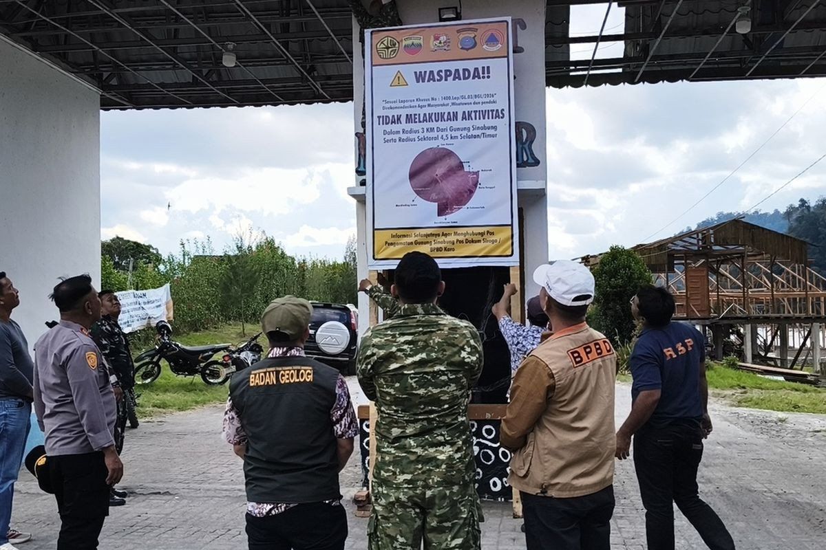
Authorities in North Sumatra's Karo regency have suspended public access to Lau Kawar Lake and an associated camping facility in Kuta Gugung village, Naman Teran district, in response to mounting concern over Mount Sinabung's geological behaviour. The decision, which took effect on August 19 with no specified end date, reflects mounting anxiety among regional officials that the 2,460-metre volcano—dormant for roughly four centuries until its dramatic reawakening a decade ago—may be approaching another dangerous phase. The Vulcanology and Geological Disaster Mitigation Center's Mount Sinabung monitoring station recommended the closure, a step endorsed by Karo Youth Affairs, Sports and Tourism Agency head Juni Antomi Kemit in a statement released on August 26.
The rationale behind this precautionary measure centres on a formal public advisory issued by the Karo regent on August 14, which urged residents, holidaymakers, and mountaineers to refrain from any activity within the volcano's vicinity. Juni characterised the temporary suspension as an essential safeguard, emphasising that the decision prioritises visitor welfare given the escalating manifestations of volcanic unrest. The timing reflects mounting seismic data that has alarmed monitoring teams tracking the mountain's behaviour continuously throughout August.
The alert status governing Mount Sinabung has been formally elevated from Level I Normal to Level II Waspada, an intermediate classification within Indonesia's four-tier volcanic hazard system. Armen Putra, who heads the Mount Sinabung monitoring command post, confirmed this upgrade, which carries significant implications for activity restrictions around the volcano. Government guidance now mandates that visitors and residents maintain a minimum distance of three kilometres from the summit, with a more stringent 4.5-kilometre exclusion zone applying specifically to the south-eastern sector of the mountain, reflecting the unpredictable direction that subsequent pyroclastic flows and ash dispersal might follow.
Communities occupying riverside settlements fed by watercourses originating on Mount Sinabung face additional warnings regarding the acute hazard posed by lahars—destructive mudflows that surge downslope without warning. These alerts were formally communicated on August 13, establishing the backdrop for subsequent precautions. The monitoring data underlying these warnings paints a picture of genuinely escalating volcanic behaviour. Armen reported that by early Thursday morning, August 27, the volcano had registered five volcanic earthquakes alongside tectonic tremors, a significant increase compared to the previous day's count of just one volcanic quake and seven tectonic events. Simultaneously, observers noted thick plumes of smoke rising 100 to 800 metres above the summit.
The seismic interpretation carries sobering implications. As Armen noted with characteristic directness, the relationship between earthquake frequency and eruption probability remains starkly linear—more tremors invariably signal greater likelihood of imminent volcanic discharge. This assessment reflects decades of instrumental monitoring and eruption prediction research. The current episode must be understood against Mount Sinabung's recent eruptive history, which has been remarkably energetic despite the volcano's four-century repose that preceded August 2010.
When Mount Sinabung first burst to life after its extended dormancy on August 29, 2010, the rupture shocked a region that had grown accustomed to regarding the peak as geologically benign. Initial activity subsided in September that year, yet the volcano remained restless. A subsequent eruption unfolded on September 15, 2013, subsequently declining by month's end. However, the most catastrophic episode arrived in November 2013, when the volcano attained maximum alert status—Level IV Awas—with devastating consequences. That eruption unleashed pyroclastic flows of scorching volcanic material that claimed dozens of lives, while authorities evacuated approximately 21 villages and two hamlets, displacing thousands from their homes.
Following that frightening interval, Mount Sinabung entered an unusually prolonged eruptive cycle spanning six consecutive years, during which considerable volcanic material continued to be ejected and communities remained under varying threat levels. Relief arrived in May 2019 when monitoring data suggested substantially diminished hazard, prompting officials to downgrade the alert status to Level III Siaga. This period of comparative stability proved temporary. In July 2021, the volcano erupted once more, dispatching ash columns reaching 4,500 metres altitude and directing pyroclastic currents up to 1,000 metres eastward and southeastward. That eruption, the most recent prior to current activity, affected multiple districts across the region, blanketing extensive areas under layers of fine volcanic debris that disrupted daily life across North Sumatra's landscape.
For Malaysian readers and regional observers, Mount Sinabung's renewed agitation carries broader significance extending beyond Indonesia's borders. The volcano sits within the Pacific Ring of Fire, a seismically and volcanically hyperactive zone encircling the Pacific Basin where the majority of Earth's volcanic activity concentrates. Southeast Asia's geological position means that major Indonesian volcanic episodes can influence atmospheric conditions, air quality, and climate patterns across Malaysia, Singapore, and neighbouring territories through ash dispersal and aerosol injection into the upper atmosphere. The region's tourism industry, particularly adventure and eco-tourism enterprises dependent upon accessible natural attractions, may face disruption if volcanic hazard escalates further.
The current alert escalation underscores the persistent challenge facing Indonesia and the broader region: balancing economic activity and tourism development against the stark realities of living in a geologically dynamic landscape. Karo regency, where Mount Sinabung dominates, has invested substantially in tourism infrastructure around attractions such as Lau Kawar Lake, which offers both scenic beauty and recreational opportunity. The indefinite closure represents a financial sacrifice that reflects authorities' judgment that visitor safety must supersede revenue generation during periods of elevated geological risk. This prioritisation, while economically painful, mirrors best practice established by volcanic crisis management agencies worldwide.
Moving forward, the situation warrants careful monitoring not merely by Indonesian specialists but by regional disaster management agencies throughout Southeast Asia. The trajectory of Mount Sinabung's activity over the coming weeks will determine whether the current Level II alert persists as a temporary precaution or escalates further. Historical precedent suggests that once this volcano's activity begins accelerating, progression toward dangerous eruption can occur relatively swiftly, as the 2013 sequence demonstrated. For residents, tourists, and the broader region, the coming period demands heightened vigilance and respect for the natural forces that continually reshape Indonesia's landscape.

