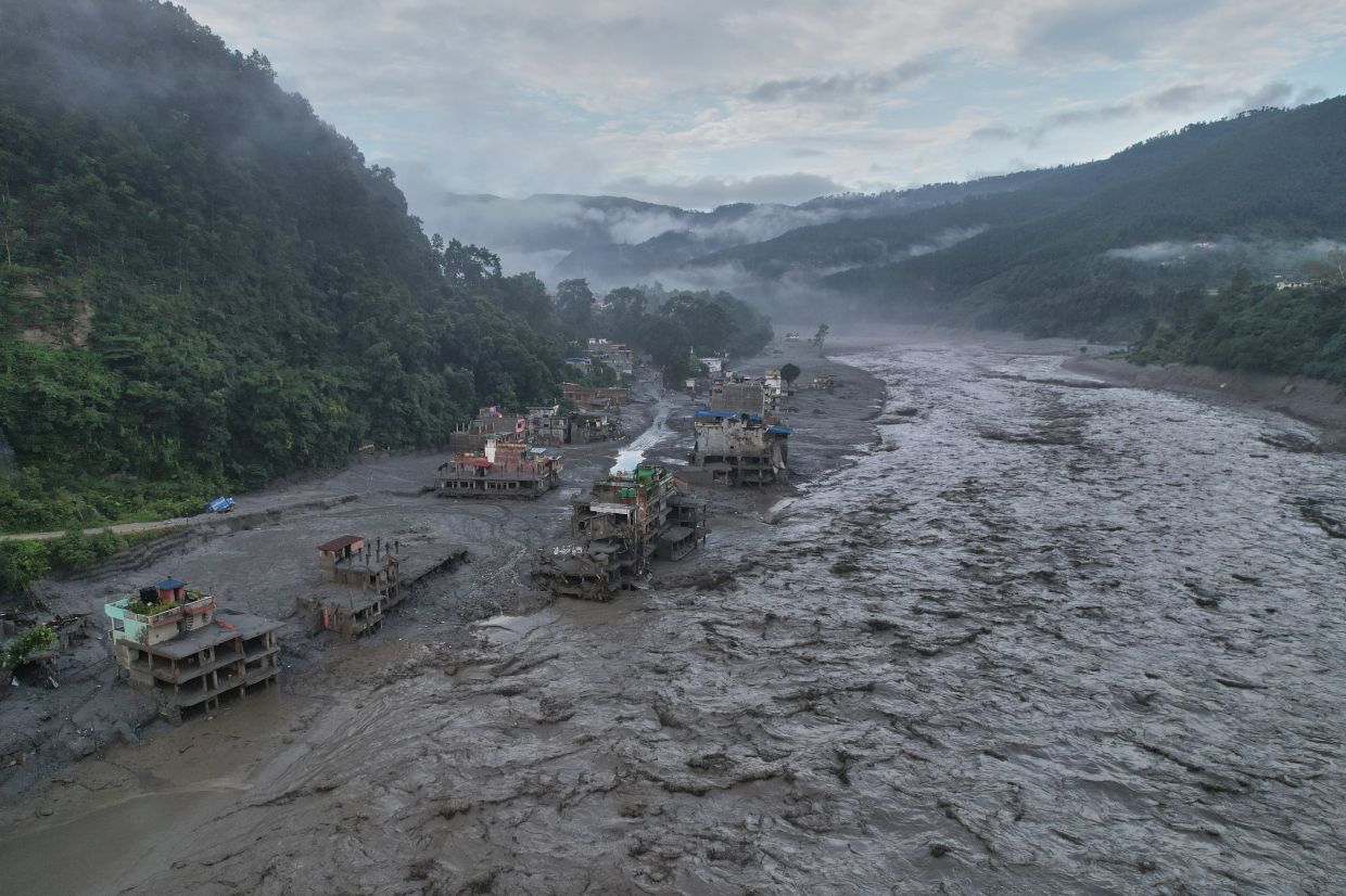
The scale of Nepal's disaster last week came with almost no advance warning. Residents affected by the devastating floods had mere minutes—sometimes fewer than five—to respond before torrents of water and debris engulfed their communities. This terrifying gap between crisis onset and public alert reveals a fundamental vulnerability in how the Himalayan nation monitors and responds to mountain-born hazards, particularly those originating in transnational watersheds where weather information remains fragmented across political boundaries.
According to Dharam Raj Uprety, who heads Nepal's National Disaster Risk Reduction and Management Authority, the absence of adequate weather stations in high-altitude regions represents one of the country's most pressing vulnerabilities. The challenge extends beyond simple infrastructure gaps: the underlying problem lies in what experts term "trans-boundary data seeding mechanisms"—the formal and informal channels through which neighbouring nations share meteorological and climate information. Without such mechanisms, weather patterns developing upstream in Tibet or across shared mountain zones cannot be effectively monitored or communicated to downstream communities at risk. Uprety emphasised this disconnect as a defining weakness, one that becomes increasingly dangerous as climate change accelerates environmental instability across the world's highest peaks.
The August 26 catastrophe itself provides a stark illustration of these monitoring failures. A glacial collapse triggered a cascade of destruction: ice, mud, rock, and fast-moving water surged through a Himalayan valley, obliterating settlements in their path. Videos captured the horrifying moment when walls of water and debris consumed entire buildings, demolished bridges and power infrastructure, and swept away vegetation, massive boulders, and vehicles as though they were debris themselves. Such disasters do not emerge suddenly without warning; they develop across hours or days through observable environmental changes. That Nepal's authorities could not detect these warning signs—or receive timely alerts from upstream monitoring points—underscores how surveillance blind spots in the high mountains translate directly into loss of life.
The economic toll compounds the human tragedy. Preliminary estimates suggest reconstruction costs could exceed US$5 billion, making this one of the most expensive natural disasters in the nation's recent history. Binod Chaudhary, Nepal's only billionaire and chairman of the Chaudhary Group conglomerate, has compared the anticipated reconstruction timeline to the seven-to-eight year process required to rebuild following the 2015 earthquake. For a developing economy heavily dependent on tourism revenue and foreign exchange, such prolonged disruption threatens not only physical infrastructure but also the livelihoods and foreign currency earnings that sustain entire regions and sectors.
China has acknowledged the regional disaster risk but stopped short of specific commitments on data sharing. Through its embassy in Kathmandu, Beijing stated that it "has always made every effort, within the limits of existing technologies, to conduct monitoring, assessment and analysis and have shared important information with the Nepali side in a timely manner." The carefully worded statement references "close communication on transboundary disaster management" without clarifying whether China provided advance warning of the August 26 event. Meanwhile, China's President Xi Jinping has called for accelerated glacier and glacial lake surveys across the Tibetan Plateau to forestall future disasters, and the Communist Party has ordered intensified monitoring and early-warning infrastructure. These directives acknowledge the scale of the challenge but remain vague regarding concrete mechanisms for bilateral data exchange.
Installing and maintaining functional weather stations at extreme altitudes presents formidable technical and financial obstacles. The harsh environment, geographic remoteness, and operational complexity of high-mountain installations place them beyond the capacity of many developing nations working alone. Moreover, equipment must survive extreme cold, permafrost variability, and limited accessibility for maintenance and repairs. These practical constraints mean that even wealthy nations struggle to achieve comprehensive coverage in remote mountain zones. For Nepal, the financial burden of developing such infrastructure independently—while simultaneously managing flood response, reconstruction, and ongoing development needs—proves nearly impossible without substantial external support and genuine data-sharing partnerships.
Beyond the infrastructure question lies a deeper scientific reality: the Himalayan environment itself is becoming more volatile and harder to predict. Warming temperatures are destabilising glaciers and mountain slopes at accelerating rates, creating new hazard types and modifying the behaviour of established risks. Satellite analysis indicates that bedrock failure beneath a glacier triggered the cascading failure on August 26. While scientists caution that attributing a specific collapse directly to climate change requires further investigation, the underlying mechanism is clear: warming weakens the permafrost that binds high-altitude slopes together, increasing the likelihood of sudden, catastrophic failure. As temperatures continue rising, these mountain-born hazards will become more frequent and more severe, demanding ever-better detection and warning systems.
Nepali authorities have begun developing response frameworks to address these gaps. The NDRRMA—the primary coordination body for disaster response—has drafted a roadmap intended for endorsement in the coming weeks. The strategy focuses on extending warning lead times so that communities have meaningful opportunity to prepare and evacuate. Uprety has stressed that unless Nepal and its neighbours adopt more transparent and systematic mechanisms for sharing climate and weather information across borders, disasters originating in remote mountain areas will remain nearly impossible to anticipate with sufficient precision to save lives. This position reflects a growing international consensus that mountain hazard management cannot succeed within national silos; the atmosphere and hydrological systems do not respect political boundaries, and neither can effective disaster response.
For Southeast Asian nations and the broader region, Nepal's experience carries urgent lessons. The Himalayas and associated mountain ranges affect weather patterns and river flows across multiple countries. Flash flooding, glacial outburst events, and landslides triggered in high mountains can affect populations hundreds of kilometres downstream across borders. Myanmar, Bangladesh, Laos, Thailand, and Cambodia all face potential hazards from mountain instability in upstream regions. The Mekong River, the Brahmaputra, and other major waterways that sustain hundreds of millions of people originate in mountain zones where monitoring remains inadequate and data sharing remains incomplete. Nepal's tragedy demonstrates that regional vulnerability to mountain-born disasters is neither a purely national problem nor one that can be solved unilaterally.
The political dimension of data sharing adds another layer of complexity. Weather information, particularly at high resolution and in strategically sensitive border regions, carries geopolitical implications that some nations view cautiously. China's measured response—acknowledging efforts to share information while emphasising limits imposed by "existing technologies"—reflects diplomatic calculation. For Nepal and other downstream nations, the challenge becomes how to negotiate access to upstream data and early warnings without appearing to compromise sovereignty or create dependencies. Building functional transnational monitoring and alert systems requires not only technical coordination but also sustained political will and trust among nations with divergent interests.
Looking forward, the imperative for action is clear. The NDRRMA roadmap represents a necessary first step, but its success will depend on resources, sustained political commitment, and willingness by neighbouring nations to share critical environmental information. International development organisations and climate financing mechanisms may need to expand support for mountain monitoring infrastructure in developing nations. At the same time, regional diplomatic frameworks—potentially through SAARC (South Asian Association for Regional Cooperation) or ad hoc bilateral agreements—must establish protocols for routine data exchange on glacial lakes, permafrost conditions, weather patterns, and emerging hazards. Without such frameworks, the tragic sequence of events in Nepal—inadequate warning, catastrophic loss of life, years of reconstruction—will inevitably repeat across the Himalayan region and beyond.

