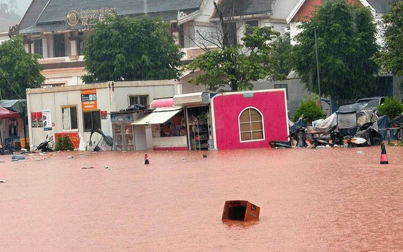
Luang Namtha province in northern Laos was officially designated a disaster zone on Saturday following catastrophic flash floods that swept through the border region, submerging villages, infrastructure and farmland across multiple districts. The provincial administrative committee made the declaration after days of intense rainfall sent surging waters through the area around Boten, the major Laos-China border crossing, with flooding affecting more than 30 villages in Luang Namtha and Nalae districts.
The scale of the inundation proved extensive, with rising floodwaters engulfing structures positioned near watercourses, damaging educational facilities and medical centres, and destroying productive agricultural land. A special economic zone in the border region also sustained significant impacts. Notably, the border checkpoint at Boten itself managed to avoid direct flooding, though the surrounding landscape bore the brunt of the deluge. The combination of flash flooding and accompanying landslides created a dual hazard that compounded destruction across the affected districts.
The immediate catalyst for the flooding originated upstream, where a succession of heavy downpours caused multiple river systems to swell dramatically. Water from these overflowing tributaries moved southward into Laotian territory, with the Tha River becoming a particular focal point. Hydrological monitoring at the Tha River station recorded water levels reaching 6.58 metres on Saturday, substantially exceeding the standard 6-metre flood warning threshold and edging perilously close to the critical 7-metre marker that signals severe flooding risk.
Responding to escalating water levels, the Department of Meteorology and Hydrology operating under Laos's Ministry of Agriculture and Environment issued formal flood warnings specifically targeting the Tha River basin for August 29-30. The alert underscored the genuine prospect of continued high water conditions through the weekend period. Provincial authorities subsequently directed administrators across five districts to mobilise alert systems for residents occupying riverbank properties, inhabiting low-lying terrain and living in other geographically vulnerable positions, with evacuation readiness becoming a priority consideration.
The disaster unfolding in Luang Namtha represents merely one manifestation of a much broader weather crisis engulfing the region. A low-pressure weather system traversing northern Laos and adjacent southwestern Chinese territory, interacting with prevailing southwest monsoon patterns, is generating dangerous meteorological conditions across a substantially larger geographic area. This atmospheric combination is anticipated to produce scattered thunderstorms interspersed with moderate to heavy precipitation and forceful wind gusts throughout the weekend.
The geographical extent of the danger becomes apparent when examining the complete risk profile. Fourteen provinces across Laos face potential weather threats, spanning from the mountainous northern regions through central areas and extending into the southern provinces. This expansive list encompasses Phongsaly, Huaphan, Luang Prabang, Luang Namtha, Oudomxay, Xaysomboun, Bolikhamxay, Khammuan, Savannakhet, Salavan, Xekong, Champasak, Attapeu and the capital region of Vientiane.
The implications for the region are significant from both humanitarian and infrastructural perspectives. For Malaysia and other Southeast Asian nations, the Laos situation illustrates the vulnerability of border regions and economic zones to extreme weather events, particularly during monsoon seasons when atmospheric instability peaks. The Boten special economic zone carries importance beyond Laos itself, serving as a crucial transshipment point for Chinese investment and trade flowing toward Thailand and broader Southeast Asian markets. Disruption to this corridor affects regional supply chains and economic connectivity.
Provinces particularly exposed include those straddling major river systems and those with substantial populations concentrated in flood-prone lowland areas. The simultaneous vulnerability of multiple provinces compounds rescue and relief coordination challenges, potentially stretching resources across Laotian authorities. Provincial officials have received explicit instructions to maintain intensive situation monitoring, mount rapid responses to emerging incidents and furnish regular situation updates to provincial headquarters. This hierarchical information flow enables better overall resource coordination and faster mobilisation of assistance where most needed.
The broader context of increasing monsoon intensity and changing precipitation patterns in the Mekong region deserves consideration. Laos, positioned along major river systems that drain vast areas of China and Tibet, experiences flooding amplified by upstream weather events. The nation's topography—characterised by mountainous terrain and river valleys—creates natural channels for rapid water concentration and accelerated runoff during heavy rainfall periods. Climate variability in recent years has intensified these phenomena, making seasonal flood management an ongoing challenge.
Residents throughout the affected provinces have been issued explicit public advisories urging heightened vigilance and active engagement with weather forecasting information. The warnings specifically emphasise the dual threats of rapidly developing flash floods and rainfall-triggered landslides, hazards that frequently materialise with minimal advance notice and can prove catastrophic in populated areas. Families residing adjacent to watercourses or in topographically depressed zones face the most acute risks and should prioritise evacuation preparations and maintain constant awareness of water level conditions.
For Malaysian observers, the Luang Namtha floods underscore several pertinent considerations. First, cross-border climate disasters demand coordinated regional responses, particularly in shared river basins. Second, economic zones and trade corridors must integrate climate resilience into their infrastructure planning. Third, Southeast Asian nations including Malaysia should strengthen meteorological cooperation and early warning systems to provide constituent populations with the maximum preparation time possible. The Luang Namtha situation, while devastating at the local level, offers instructive lessons about climate vulnerability that extend throughout the subregion and into Malaysia's own monsoon seasons.

