Japan's weather authorities issued urgent warnings on Friday as the country confronted an unusual dual typhoon scenario, with Typhoon Higos poised to make landfall over the weekend while Typhoon Mekkhala simultaneously threatened multiple regions. The Japan Meteorological Agency alerted the public to prepare for the convergence of both weather systems, even as torrential rains were already hammering western and eastern prefectures, creating a compounding disaster risk for densely populated areas.
The situation posed a rare meteorological challenge, with Typhoon Mekkhala already impacting the Amami region in Kagoshima Prefecture in southwestern Japan on Friday morning, while simultaneously positioning itself to sweep toward the Kanto region—home to Tokyo and surrounding metropolitan areas—by Saturday. This configuration meant that parts of Japan would face sequential or overlapping periods of extreme weather, preventing adequate recovery time between systems and stretching emergency response capabilities across multiple fronts.
By Friday morning, the Fire and Disaster Management Agency reported that evacuation orders had been issued affecting over 2 million people distributed across 13 prefectures spanning the Kinki and Kyushu regions. The scale of the evacuation underscored the severity officials anticipated, reflecting decades of experience managing Japan's typhoon season. In Seika, Kyoto Prefecture, authorities implemented the highest level 5 emergency safety alert for specific neighborhoods after a landslide struck during the early morning hours, signalling that geomorphological hazards were already materializing despite the primary systems still approaching.
Rainfall data collected over the preceding days illustrated the extraordinary precipitation already inundating the region. Between Tuesday and Friday morning, Goto in Nagasaki Prefecture accumulated 600 millimetres of rain, while Aso in Kumamoto Prefecture and Ureshino in Saga Prefecture each recorded more than 500 millimetres. These cumulative totals represented roughly half the typical annual rainfall in many Japanese locales, saturating soil and groundwater systems and dramatically elevating landslide risk regardless of additional rainfall.
The Japan Meteorological Agency projected that both Typhoon Higos and Typhoon Mekkhala would gradually weaken and transition into extratropical cyclones as they moved across or near Japan. However, meteorologists cautioned that this transition would not eliminate hazards; the resulting systems could still generate dangerous flooding, flash flooding in valleys and urban drainage systems, and continued landslide activity. The agency explicitly urged residents and local authorities to maintain heightened vigilance for these secondary effects even after wind speeds declined.
Rainfall forecasts for the critical Saturday period painted a picture of intensifying precipitation across central and eastern Japan. The Tokai region, stretching across central Honshu and encompassing major industrial centers, was expected to receive up to 300 millimetres by noon Saturday. The Kanto-Koshin region—which includes Tokyo and extends north toward mountainous terrain prone to flooding—was predicted to accumulate up to 150 millimetres. These incremental additions to already-saturated conditions would likely trigger additional slope failures and overwhelm stormwater systems in urban areas.
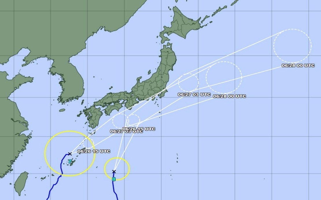
As Friday progressed toward midday, Typhoon Mekkhala positioned itself off Kume Island near Okinawa Prefecture, advancing northeast at 15 kilometres per hour. This trajectory indicated the system would curve toward the main Japanese islands within hours, bringing its full precipitation potential to populated regions. The timing suggested the most intense period of rainfall from this system would occur Friday evening through early Saturday, with Typhoon Higos approaching simultaneously from the south.
The convergence of these weather systems held particular significance for Southeast Asia beyond Japan's borders. Typhoon tracking corridors and seasonal patterns mean that systems affecting Japan can influence regional weather elsewhere in Asia-Pacific, and Japan's response protocols and damage assessments provide early indicators for neighbouring countries in similar monsoon and typhoon zones. Malaysian and Philippine meteorologists routinely monitor Japanese typhoon activity to refine regional forecasting and prepare their own populations, making Japan's crisis a bellwether for the broader region's hurricane season.
For Malaysian readers and regional observers, the Japanese situation underscores the escalating intensity of extreme weather events across Asia-Pacific. While Japan benefits from sophisticated early warning systems, advanced emergency management infrastructure, and compulsory evacuation procedures, the scale of displacement—over 2 million people—demonstrates how even well-prepared nations face enormous logistical and humanitarian challenges when multiple severe systems converge. The lesson resonates across Southeast Asia, where similar dual-typhoon scenarios could prove catastrophic in areas with less developed warning systems or evacuation capacity.