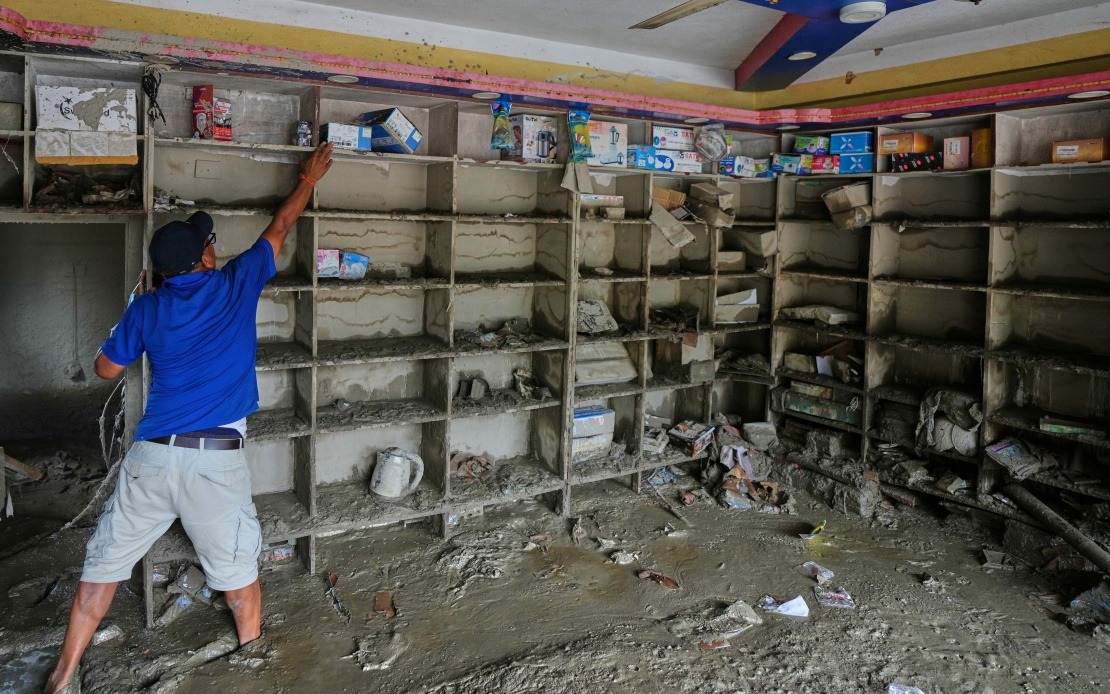
A devastating mudslide that struck Gyirong Port in China's Xizang Autonomous Region on August 26 originated from a glacier collapse across the border in Nepal, regional authorities confirmed Sunday following an investigation by leading seismic and climate scientists. The disaster, which has claimed at least 16 lives and left over 500 people unaccounted for, represents a grim reminder of the environmental pressures mounting across the Himalayan region as climate change accelerates glacial retreat and destabilises mountain systems throughout Asia.
The catastrophe began when a glacier perched on the southern face of Mount Langtang Lirung ruptured at approximately 5,200 metres above sea level. This fracture, occurring in one of Nepal's most prominent alpine zones, released an enormous mass of ice, rock, and debris that immediately gained destructive momentum as it descended the steep mountainside. Chinese Academy of Sciences researchers, mobilising a specialised team from the Institute of Mountain Hazards and Environment, determined the sequence through sophisticated remote-sensing analysis and fieldwork conducted at the disaster zone.
The initial avalanche descended rapidly to around 4,000 metres, where the combined forces of gravity, momentum, and the friction-generated heat from the grinding ice and stone transformed the falling debris into a massive mudslide. As this debris flow hurtled down the valley, it accumulated additional material—loose soil, vegetation, and rock fragments—along its 22-kilometre path, continuously expanding in volume and destructive potential. By the time the surging wall of mud and rock reached Gyirong Port, situated at approximately 1,800 metres elevation, it had evolved into an unstoppable force capable of obliterating everything in its trajectory.
The physical destruction wrought across the port area covered approximately 0.7 square kilometres, a testament to the force of the deluge. Twenty-seven structures, encompassing residential buildings and associated infrastructure critical to the community's functioning, were completely flattened. For residents and workers at this strategic border crossing linking Nepal and Tibet, the disaster struck with virtually no warning, leaving little opportunity for evacuation despite modern meteorological capabilities. The scale of the catastrophe reflects not merely the destructive energy of nature but also the vulnerability of settlements positioned beneath unstable geological features.
By Saturday evening, the confirmed death toll stood at 16 individuals, though regional authorities acknowledged that 546 people remained missing and presumed dead, suggesting the final casualty figures could rise substantially once recovery operations concluded. The missing persons reflected both those buried beneath the debris and individuals swept away by the torrent, making recovery efforts extraordinarily challenging. Families and officials faced an agonising period of uncertainty as search teams navigated treacherous terrain and unstable debris fields to locate survivors or retrieve remains.
The investigative conclusions emerged from comprehensive analysis conducted by China's premier glaciology and disaster response experts. The research team employed cutting-edge remote-sensing technology to reconstruct the avalanche's trajectory and compare satellite imagery captured before and after the event. Combined with fieldwork examining the debris field itself and data transmitted from monitoring stations, this multi-disciplinary approach provided definitive evidence linking the mudslide directly to the Nepalese glacier rupture. Such scientific rigour underscores Beijing's investment in sophisticated environmental monitoring systems across the Tibetan plateau and bordering regions.
For Malaysia and Southeast Asian nations, this incident carries important implications regarding climate-induced natural disasters and transboundary environmental risks. The Himalayan region supplies water to billions of people across Asia, including communities throughout Southeast Asia via major river systems. As glacial retreat accelerates due to rising temperatures, similar catastrophic failures could become increasingly frequent, affecting water security, hydroelectric generation, and disaster preparedness planning. The scientific findings highlight how geological and climatic instability in distant mountains can have far-reaching consequences across the continent.
The Gyirong Port mudslide also illustrates the particular vulnerability of border communities and trade corridors. As an important commercial crossing connecting South and East Asia, damage to the port's infrastructure disrupted regional trade flows during critical investigation and recovery phases. Such strategic locations, while economically vital, often face heightened exposure to natural hazards due to their positioning in challenging terrain. The incident underscores the necessity for enhanced cross-border cooperation on environmental monitoring and disaster preparedness between Nepal, China, and other regional stakeholders.
Climate scientists warn that Mount Langtang Lirung and similar glaciers across the Himalayas face ongoing destabilisation as global temperatures continue rising. The phenomenon of glacial lake outburst floods and avalanche-generated mudslides represents an emerging class of climate-related disasters that pose particular challenges for conventional disaster response frameworks. Traditional early-warning systems, optimised for rainfall-triggered flooding or seasonal hazards, struggle to predict sudden avalanches initiated by glacial fracturing, leaving communities with minimal preparation time. This scientific reality demands investment in upgraded monitoring technology and cross-border information-sharing protocols.
The investigation's findings also carry relevance for infrastructure planners and government officials throughout the Himalayan region and beyond. Communities situated downstream from high-altitude glaciers require updated hazard assessments reflecting contemporary climate conditions rather than historical baselines. Building codes, land-use planning, and emergency protocols must adapt to acknowledge the accelerating pace of environmental change. For Southeast Asian nations with mountainous regions and glaciated peaks—though none comparable to the Himalayas in scale—the Gyirong Port disaster provides cautionary evidence regarding the need for sustained investment in geological monitoring and community preparedness systems.

