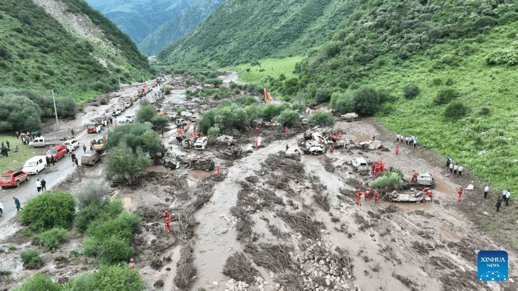
A devastating flash flood struck a popular tourist destination in northwest China's Gansu Province on Sunday afternoon, claiming at least 10 lives and leaving 23 others injured, according to local government officials. The disaster unfolded in Weiyuan County within Dingxi City when sudden torrential rainfall overwhelmed the scenic area where tourists had gathered for camping. The rapid onset of the floodwaters caught many visitors off guard, trapping them in the region as rescue operations commenced immediately. Provincial authorities deployed public security personnel and fire-and-rescue teams to conduct intensive search-and-rescue missions throughout the evening, with the death toll and injury figures confirmed at 6 pm local time.
The catastrophic flooding in Gansu forms part of a broader weather crisis affecting much of China as Typhoon Noul—the year's strongest tropical cyclone—crosses the nation with destructive force. The typhoon, whose name derives from a Korean term meaning the glow of sunrise or sunset, made landfall in Guangdong's Huidong County at approximately 3:50 am on Sunday morning, marking China's third typhoon of the month. In the hours following its arrival, the storm battered Guangdong Province and neighbouring Hong Kong with destructive gale-force winds before gradually weakening as it progressed inland. The Hong Kong Observatory confirmed that the typhoon had passed within 80 kilometres of the Asian financial hub, generating severe southwesterly gales that affected large portions of the territory before all warning signals were cancelled by Sunday evening.
China's water resources authorities responded to the escalating threat by issuing the nation's highest-level alert for flash floods across multiple provinces. The Ministry of Water Resources and the China Meteorological Administration jointly released a red warning, the most severe classification in the nation's alert system, identifying seven provinces at heightened risk. The alert encompasses Jiangxi, Hunan, Guangdong, Sichuan, Shaanxi, Gansu, and southeastern Xinjiang, with the period of greatest danger spanning from Sunday evening through Monday evening. Meteorological forecasters anticipate that heavy to torrential rainfall will continue across much of southern China for at least the next two days as Typhoon Noul's atmospheric circulation interacts with regional weather patterns. Some areas, particularly in Fujian Province, face the prospect of extremely heavy precipitation that could trigger additional flooding incidents.
The scale of preventative measures undertaken by Chinese authorities underscores the severity of the situation. More than 700,000 residents across Guangdong Province have been relocated from flood-prone and typhoon-vulnerable areas, representing one of the largest evacuation operations mounted in response to this year's severe weather events. Government officials have issued explicit directives to local administrations to maintain heightened vigilance over particularly hazardous locations, including mountainous regions, river valleys, construction sites, and bridge infrastructure where flooding and structural failures pose acute risks. The public has been advised to monitor real-time warnings and follow evacuation instructions to minimise casualties and property damage as the weather system continues its progression through the country.
For Malaysia and Southeast Asia, Typhoon Noul serves as a sobering reminder of the region's vulnerability to tropical cyclones and the cascading risks they generate. While the immediate impact remains confined to southern China, the typhoon's trajectory and intensity reflect broader patterns of extreme weather affecting the wider region. Southeast Asian nations, particularly those with vulnerable populations in flood-prone areas, should review their own disaster preparedness protocols and early warning systems in light of China's experience. The coordination demonstrated between China's water resources ministry and meteorological administration offers a model for regional cooperation, as typhoons frequently impact multiple countries within the Southeast Asian sphere.
The Gansu flash flood tragedy reveals how rapidly weather conditions can transform from manageable to catastrophic, particularly in scenic mountain areas where tourists gather. The concentration of visitors in narrow valleys during rainfall events creates compounded risk, as evacuation becomes difficult once water levels rise sharply. This incident may prompt Chinese authorities to reassess safety protocols at popular tourist destinations in mountainous regions, particularly those lacking robust drainage infrastructure or early warning systems. Similar vulnerabilities likely exist across Southeast Asia, where tourism and outdoor recreation frequently occur in geographically hazardous locations.
Typhoon Noul's classification as the year's 12th tropical cyclone and China's third typhoon within a single month points to a pattern of intense storm activity during the current season. This frequency suggests that atmospheric conditions across the western Pacific are particularly conducive to cyclone formation and intensification. Regional meteorological agencies have noted that climate variability continues to influence typhoon characteristics, including their intensity and precipitation patterns. For policy makers across Southeast Asia, this heightened activity underscores the necessity for sustained investment in climate adaptation infrastructure, disaster risk reduction frameworks, and scientific capacity to predict and respond to extreme weather events.
The Hong Kong Observatory's confirmation that Typhoon Noul passed within 80 kilometres of the territory demonstrates how major population centres remain exposed to tropical cyclone hazards despite advanced monitoring capabilities. Although Hong Kong successfully implemented protective measures and cancelled warning signals within hours of the typhoon's closest approach, the incident highlights the narrow margins of safety that exist in densely populated coastal regions. The brief suspension of Hong Kong's airport operations—lasting more than 12 hours before gradual resumption began on Sunday afternoon—illustrates the significant disruption that major typhoons inflict on regional transportation networks and economic activity.
Weather forecasts indicate that rainfall will persist until at least Tuesday across the affected regions, meaning that the flood risk will remain elevated for several additional days. Authorities have warned that secondary flooding could occur as water from upland areas gradually flows toward river systems and low-lying communities. The combination of saturated ground conditions and continued rainfall significantly increases the likelihood of additional flash floods, landslides, and structural failures in vulnerable areas. Rescue teams will likely continue intensive operations throughout Monday and potentially into Tuesday as they search for missing persons and respond to new incidents triggered by the continuing precipitation.

