Starting from July 1, Kuala Lumpur City Hall has implemented the permanent closure of two signalised intersections along Jalan Ampang: one directly in front of the Royal Thai Embassy and another at Lorong Ampang 2. The move marks the commencement of a comprehensive upgrade initiative spanning 3.2 kilometres, extending from the Jalan Tun Razak junction through to the Middle Ring Road 2 (MRR2) connection.
The broader Jalan Ampang upgrade project represents a significant infrastructure intervention aimed at enhancing the operational capacity of one of Kuala Lumpur's major east-west corridors. According to the municipal authority, the initiative seeks to achieve multiple objectives simultaneously: increasing road network efficiency, bolstering user safety standards, and facilitating smoother traffic progression along this important thoroughfare that connects multiple commercial, residential, and institutional precincts.
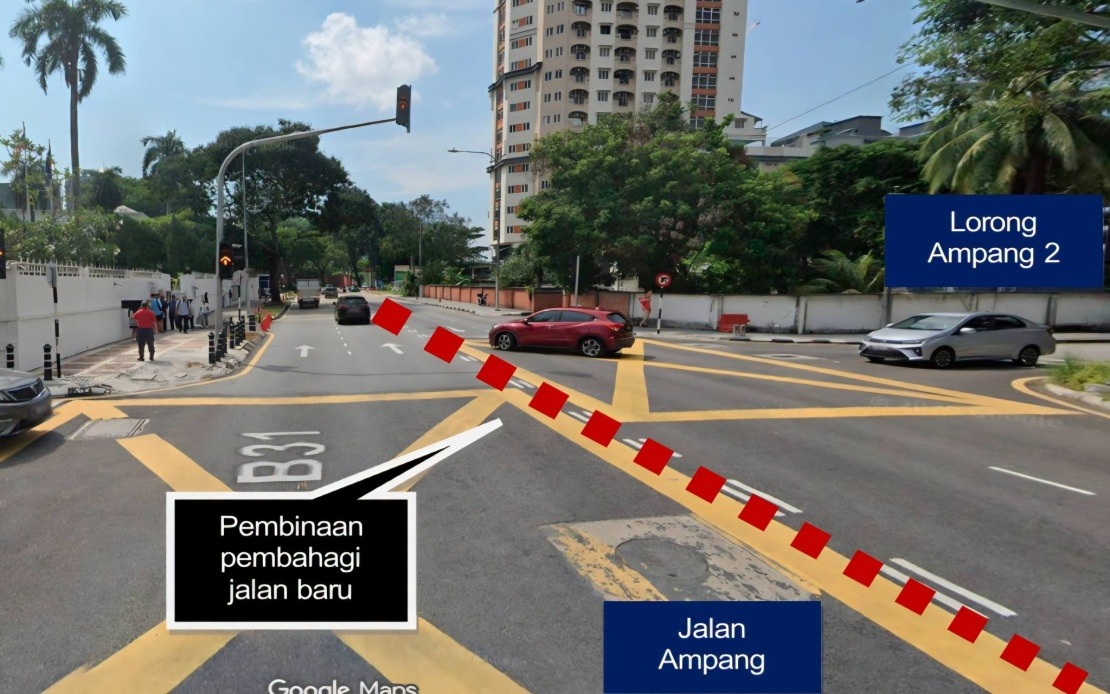
At its core, the project introduces a modernised road hierarchy and safety framework. The planned improvements encompass the installation of systematic road dividers that will prevent informal lane-switching and reduce conflict points between opposing traffic streams. The reconfiguration will establish two-way four-lane roadways, providing greater capacity and predictability for motorists. Complementing these structural changes are enhancements to pedestrian infrastructure—wider, more comfortable walkways designed with user safety as a priority—alongside upgraded street lighting systems that improve visibility during evening hours and inclement weather.
The closure of the two traffic light intersections forms an integral component of this traffic management strategy. By removing these signalised nodes, traffic engineers anticipate a reduction in the weaving behaviour that typically occurs when vehicles attempt to change lanes immediately before or after controlled intersections. Such conflicts frequently create bottlenecks and cascade delays throughout adjacent road sections. The elimination of these conflict zones should theoretically improve traffic flow consistency and reduce the cumulative delay experienced by commuters traversing the corridor.
For motorists and residents accustomed to the existing intersection configurations, DBKL has introduced alternative routing protocols to maintain accessibility to surrounding areas. Those originating from the city direction and requiring access to Ampang may perform a U-turn at Jalan Tun Razak, from which point they can re-enter Jalan Ampang eastbound. Conversely, vehicles travelling from Ampang towards the central business district can execute a U-turn at Jalan Ampang Hilir to redirect their journeys cityward. These designated alternatives aim to distribute diverted traffic across existing road capacity without overwhelming any single parallel route.
The timing and implementation of this project carry implications for several stakeholder groups within the greater Klang Valley region. For daily commuters, the closure period may initially impose minor route adjustments and travel time variability, though project authorities contend these temporary inconveniences will yield sustained improvements once construction concludes. Commercial establishments fronting Jalan Ampang, including the diplomatic mission at the Royal Thai Embassy, require coordination to ensure continued accessibility despite the intersection reconfiguration. Similarly, residents of the Ampang township and surrounding neighbourhoods must adapt to modified traffic patterns, particularly during peak commuting windows.
The geographic scope of the upgrade—stretching from Jalan Tun Razak to MRR2—suggests that the intersection closures represent merely the initial phase of a broader systematic intervention. The full project may involve sequential closures and reconstructions across multiple segments, potentially extending the period during which traffic patterns remain unsettled. Motorists and residents should anticipate that additional modifications may be announced as subsequent phases progress.
Public compliance with newly installed traffic signage will prove crucial to the success of this transition. DBKL has specifically advised all road users to observe the directional and cautionary markings that now guide traffic flow around the closed intersections. Failure to respect these instructions could result in congestion at alternative junction points or, more seriously, traffic incidents resulting from driver confusion or non-compliance.
From a broader urban planning perspective, the Jalan Ampang upgrade exemplifies the ongoing effort by municipal authorities to incrementally modernise Kuala Lumpur's arterial road network. Rather than undertaking wholesale reconstruction of major corridors—an approach that would impose months or years of severe disruption—the targeted approach of closing specific problematic intersections while simultaneously enhancing surrounding infrastructure allows the city to remain functionally operational whilst improvements take effect. This methodology balances the competing demands of developmental progress and operational continuity, though it necessarily requires the public to exercise patience and flexibility during transition periods.
Residents and commuters should remain vigilant for official announcements regarding the timeline for project completion and the anticipated reopening or reconfiguration of affected intersections. DBKL is expected to provide periodic updates on construction progress and any additional temporary measures that may become necessary. For those unfamiliar with the new routes or concerned about specific journey impacts, the municipal authority has indicated its willingness to provide guidance and clarification regarding the alternative routing arrangements and traffic management protocols now in effect.